
A New Way to See Buildings: 3D Gaussian Splatting (3DGS) for Architecture, Construction & Heritage
Buildings aren't just structures. They are experiences, sequences, materials, atmospheres, and stories. And yet, most of the tools used to document, communicate and explore them reduce that richness down to something partial: a still image, a fixed 360° view, a synthetic 3D model, LiDAR point cloud or a guided video that can only be watched, not explored.
Table Of Contents
1 Introduction
2 What Gaussian Splatting Is
3 Why It's Different
4 Where It Fits
5 Architectural Value
6 For Contractors & Estates
7 Examples
8 Links to Models
9 Workflow
10 Commissioning Guide
11 Engagement Options
12 Conclusion
13 FAQ
14 Get in Touch
TLDR: Photographic 3D You Can Explore Freely
Gaussian Splatting creates photorealistic 3D models of buildings that you can explore from any angle. Unlike sometimes synthetic looking 3D meshes, which can flatten light and simplify, or video walkthroughs, which lock you into a single path, Gaussian Splatting (3DGS) preserves true photographic quality: material, texture, lighting, atmosphere, while giving viewers complete freedom of movement.
It works in modern browsers, integrates with online platforms, 360° tours, and is now used for:
architecture & design communication
house and apartment sales
heritage or site documentation
construction progress
estates and campus visualisation
public engagement and exhibitions
Gaussian Splatting has moved from research papers into practical, professional use and it's one of the most significant advances in 3D visual documentation in years.
1. Introduction: Why We Need a New Way to See Buildings
Buildings and spaces often need to be communicated to more people in more ways: remote teams, investors, public consultations, training, marketing, award judges.
Photos show one view.
A short film shows one edited narrative.
3D mesh models show geometry, but can be slow to load or flat looking. None of these show how a building actually looks while letting people explore freely across all platforms.
Clients and investors are often remote
Complex spaces can be hard to explain with photos alone
Marketing needs to show what a building actually feels like
Training and handover requires people to understand layouts quickly
Heritage sites need sustainable ways to share at-risk spaces
Condition records need to capture more than geometry
Gaussian Splatting addresses these gaps: a way to explore buildings and spaces that looks photographic, is fully interactive, is easy to deploy and feels intuitive to use.
2. What Gaussian Splatting Is
Gaussian Splatting (3DGS) is a technique that uses real photographs to reconstruct a building as a freely explorable 3D model.
It doesn't build polygons, meshes or geometry like a normal mesh model.
And it doesn't hallucinate content like generative AI renders.
Instead, it creates millions of tiny ellipsoids, called Gaussians, each carrying colour, transparency and light information taken directly from the photographs.
The result is a model that looks like real photography, but behaves like a space you can move through.
2A. The Simple Version
Gaussian Splatting turns hundreds or thousands of photographs into a 3D model that:
Looks photographic
Preserves real materials
Preserves real lighting
Allows free, natural movement
Works in any modern web browser or offline
Loads and renders in real time
You can walk through, fly around, step closer, move back, just as you would in real life.
2B. For the Technically Curious
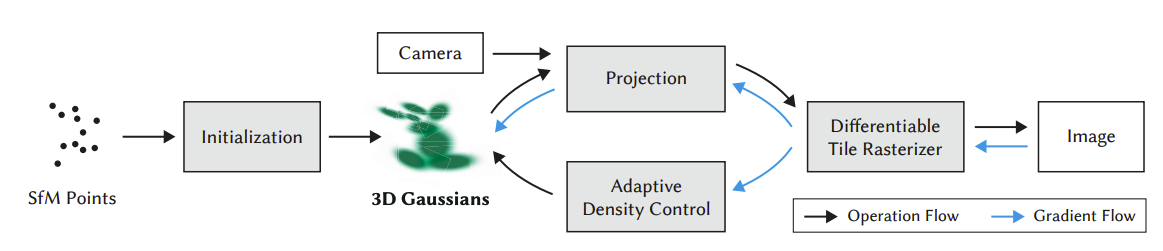
3DGS is a process of:
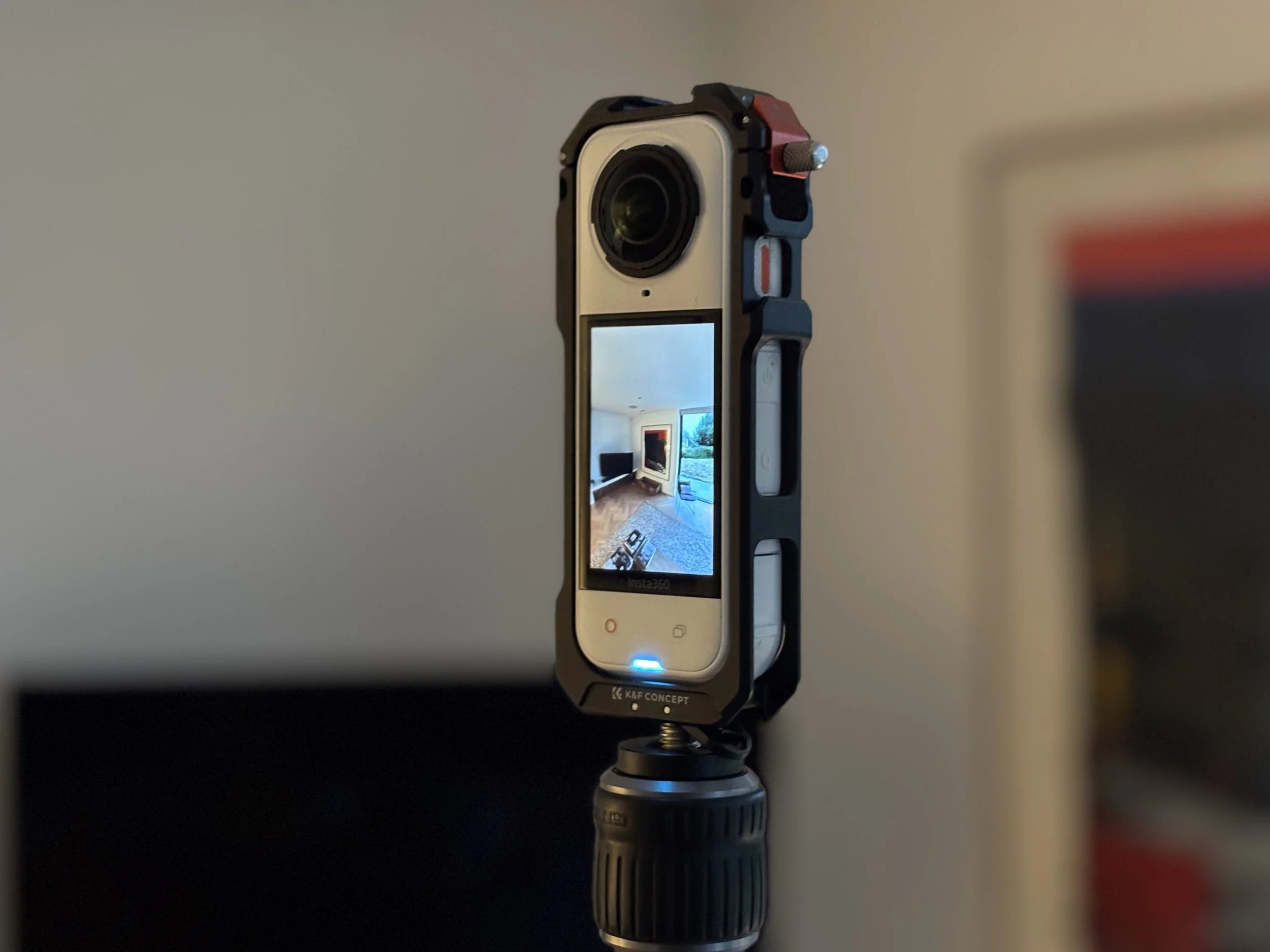
Capturing the building from many angles with ground and or drone (UAV) photography
Analysing the images using Structure from Motion (SfM), Ground Tags and GPS to determine camera positions and create an initial sparse point cloud
Reconstructing the scene using millions of Gaussian splats positioned in 3D space
Assigning properties to each Gaussian:
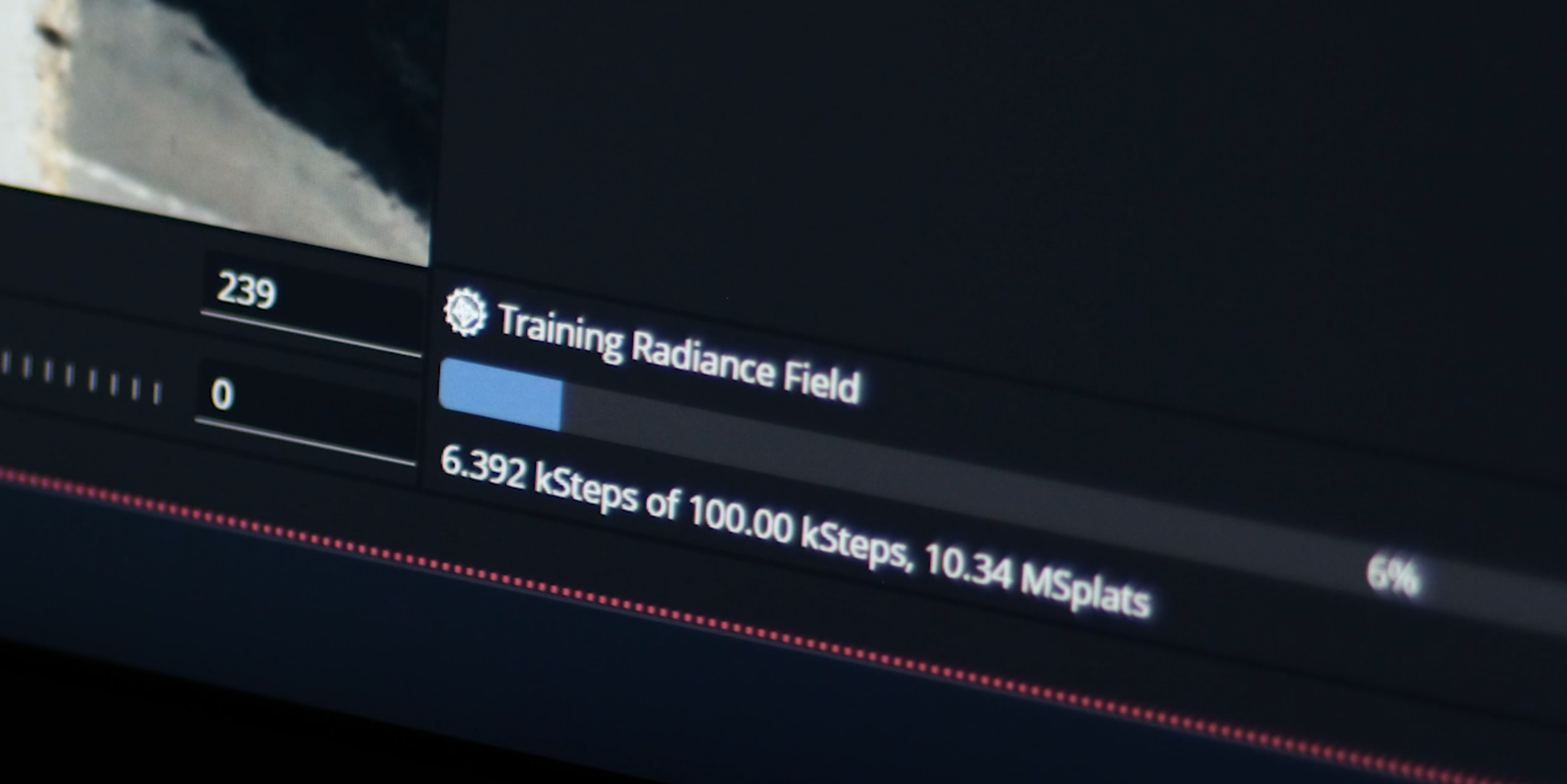
Optimising these Gaussians through machine learning training that minimises differences between the rendered views and the original photographs.
Because the model is built from real images it preserves:
transparency (such as glass)
reflections
shadows
surface irregularities
atmospheric light
material character
It is not a simple point cloud. It is not a mesh. It is not generative AI.
It is a photographic reconstruction you can explore.
3. Why Gaussian Splatting Is Different From Traditional Methods
For years, the built environment has relied on established methods for visualisation and documentation. Each is useful, but each leaves something out.
Gaussian Splatting fills a gap between them.
3A. Traditional 3D, Photogrammetry Mesh
Traditional mesh models work well for most solid surfaces and can integrate into workflows for survey and BIM applications.
But 3DGS has significant and specific visual advantages:
Real-time rendering: smooth movement and navigation on all devices without long loading delays.
Reflective surfaces: glass, polished stone, and other materials render accurately because 3DGS captures how they change appearance as you move
Transparency: windows and glazing look like real glass, not melted textures
Fine detail: wires, foliage, thin structures, and complex geometry that mesh struggles to reconstruct
View-dependent appearance: surfaces look different from various angles, just as they do in reality
3B. Video Walkthroughs, Drone Footage, Short Films
Video guides the viewer through the space and story, but is different to Gaussian Splatting because:
the route is fixed
the viewer cannot explore angles or approach details that are not included in the final edit
perspective and what you see belongs to the filmmaker or editor, not the viewer
Beautiful, creative and story rich but not interactive.
3C. 360° Virtual Tours
360 panoramas allow rotation from fixed positions, often used for:
public engagement
estates teams
interior documentation
But users jump from hotspot to hotspot; they cannot move freely in 3D space.
The exploration isn't continuous but defined by the set camera positions.
3D. Gaussian Splatting (A New Category)
The beauty of 3DGS is that it offers a combination none of the above can deliver all at once:
the realism of photography
the freedom of 3D Mesh
the intuitiveness of a virtual tour
It reconstructs space as it really appears. Textures, transparency, light, shadow and lets users explore at their own pace.
It doesn't replace traditional tools, It completes them.
4. Where Gaussian Splatting Fits in Building Documentation
No single visual tool solves every problem. Laser scanning excels at measurement. Photography excels at atmosphere. 360° tours excel at marketing. Video excels at linear storytelling.
Gaussian Splatting sits between these tools, offering a balance that didn't previously exist.
Below is a high-level comparison to help you understand where 3DGS fits.
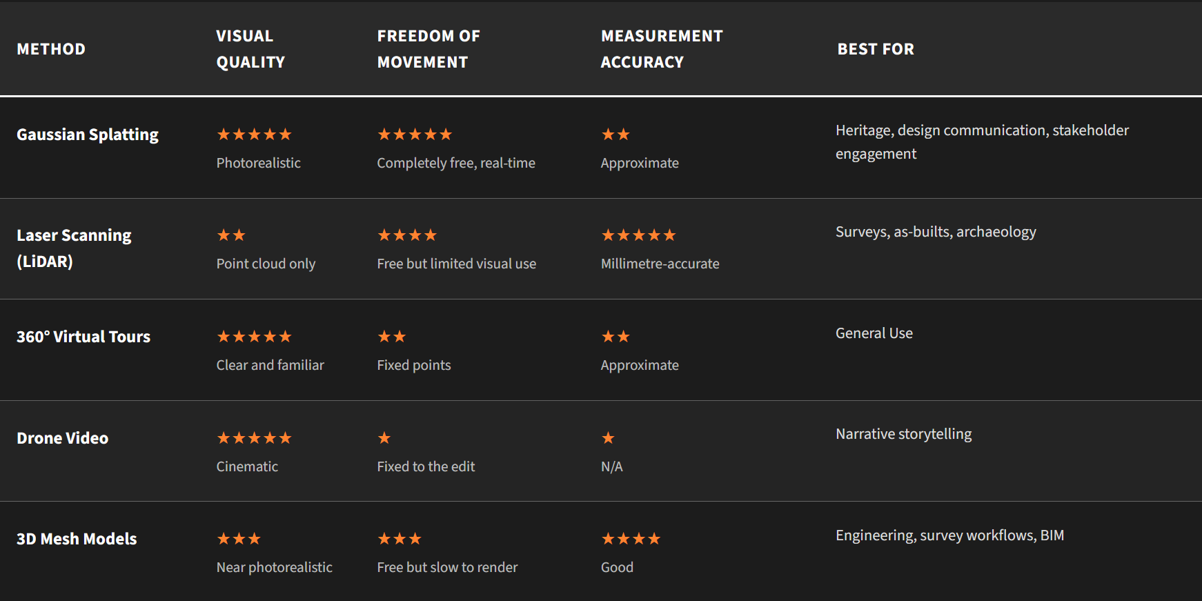
Why This Matters
Gaussian Splatting offers:
more realism than 3D meshes
more freedom than images or video
more atmosphere than lidar and point clouds
more flexibility than 360° tours alone
It won't replace LiDAR, photography or video. It complements them, filling the gap where other methods fall short.
5. What Architects Gain: The Architectural Value of Gaussian Splatting
Architecture lives in qualities that can be difficult to communicate in 3D: material, texture, shadow, sequence, proportion and atmosphere. Most 3D tools don't capture these qualities or remove them entirely. Gaussian Splatting preserves them.
The best way to explain this isn't with a diagram, it's with a story.
The Story of a Building That Didn't Want to Be Simplified
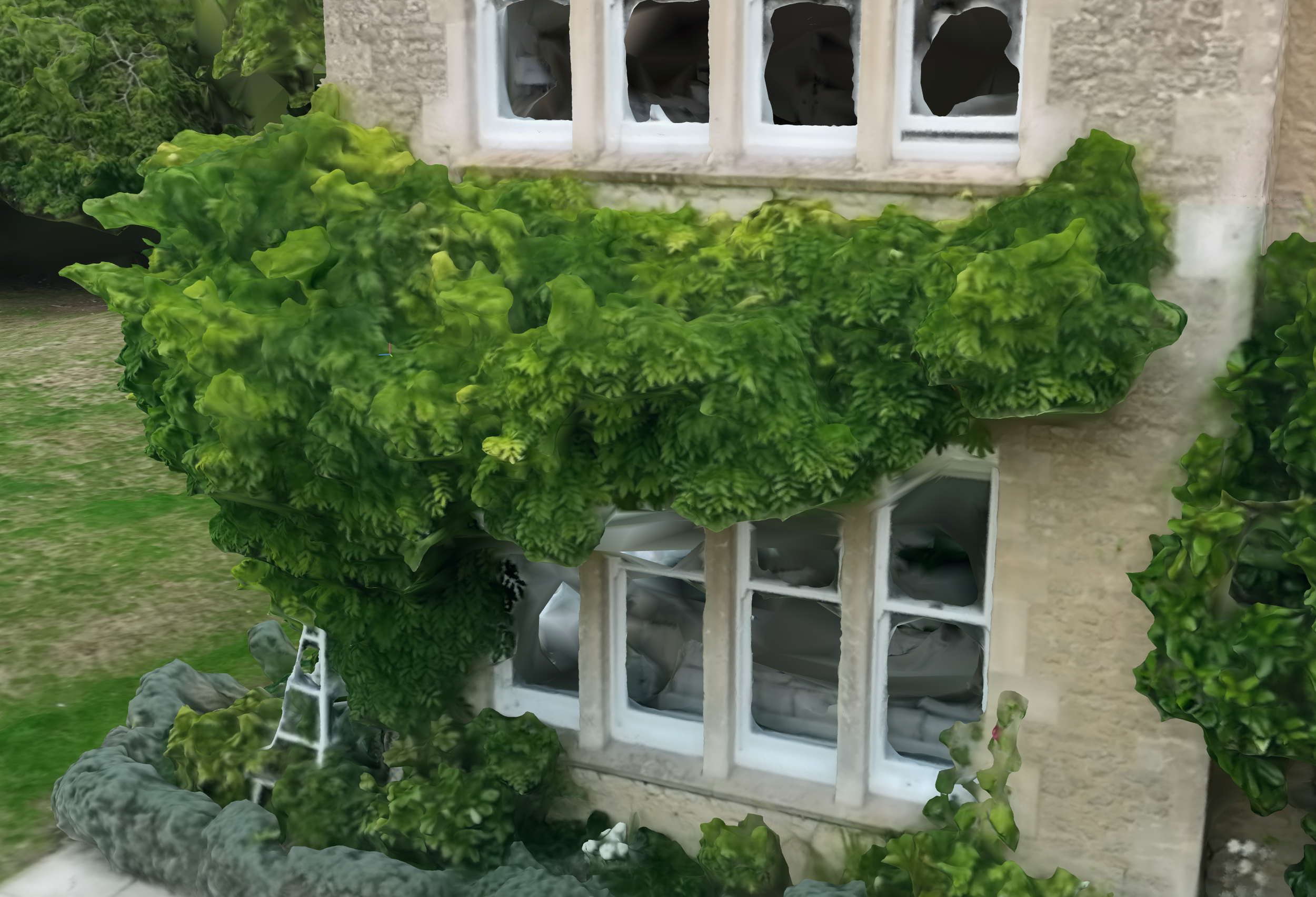
An architect restored an old residence with a carriage house. Textured stone, mature trees, and grounds that had developed over decades. But when we attempted to present the building using conventional methods, something important was missing.
A mesh model was geometrically correct but visually missing something.
Stone textures and other fine details lost their character. Its mature wooded grounds and planting lost the texture of the leaves and trees. It carried the dimensions of the structure, but the feeling was lost.
Photography captured character but not the relationship of the whole site.
Still images were beautiful, but static. The wider context of the site was missing.
When we captured the exterior of the building using Gaussian Splatting, there was a significant difference.
Materials looked like they do in real life. Stone textures and other fine details had real life to them. Its trees were shown with their full realism.
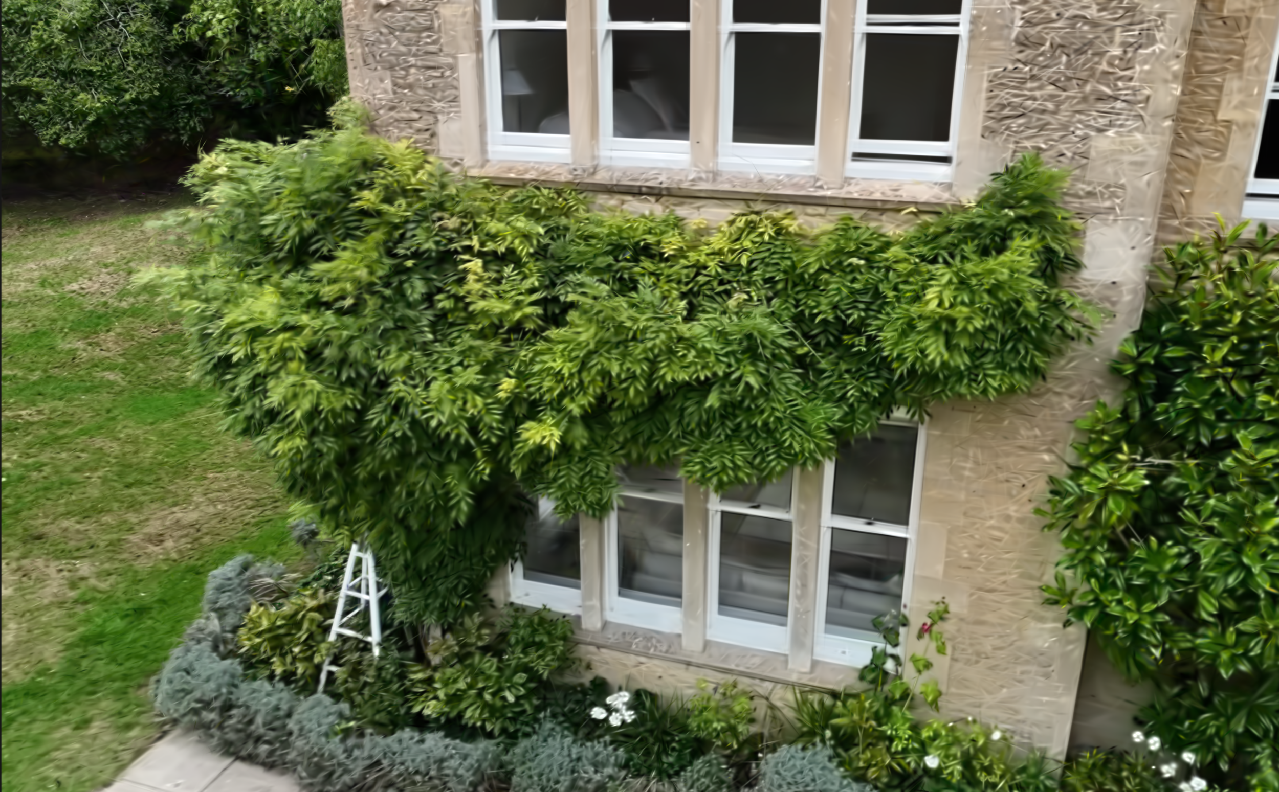
Using the same dataset (photos), a 3DGS model can show a far greater level of realism. The whole site was captured as it appears in real life.
When the clients finally saw the results.
One said: "It revealed truly impressive detail and quality"
That is the architectural value of Gaussian Splatting: It shows the building as it actually looks.
Why Architects Benefit From Gaussian Splatting
• Materials Look Like They Do in Real Life
3DGS preserves texture, material, imperfections and patina.
• Light Falls Where It Actually Falls
Lighting defines architecture. 3DGS retains real-world shadows, transmission and reflection.
• Spatial Understanding Improves Dramatically
When viewing a 3D model, Clients and non-architects can interpret scale, depth, sequence and spatial relationships better than a GA drawing or photograph.
• The Feel of the Space Is Captured
3DGS captures the building's presence; the quality that can disappear in translation to 2D images.
• Viewers Believe What They See
Viewers believe what looks real. 3DGS feels immediate and truthful.
Visual communication becomes simpler. Explanations become shorter. Decision-making becomes faster.
6. Why Estates, FM, Construction & Heritage Teams Care
Gaussian Splatting isn't only for architects or new buildings.
Its clarity and realism also make it valuable for estates, campuses, contractors, and heritage bodies, sectors where documentation must be visually reliable and immediately accessible.
Below are the scenarios where 3DGS provides practical, operational benefits.
6A. Construction & Contractors: Progress You Can Actually See
Construction generates significant technical visual data but some stakeholders often struggle to interpret it.
Gaussian Splatting supports contractors by providing:
• Remote walkthroughs that feel real
Clients can see the site as if they were standing in it.
• Fewer site visits
Teams can share details remotely without guesswork or complicated assets.
Why contractors care: It reduces friction, travel, delays and misunderstandings.
6B. Estates & Facilities Management: A Clearer Record of Your Buildings
Large estates, from commercial campuses to university departments, rely on coherent documentation.
3DGS unifies what is usually fragmented across drawings, photos, videos and maps.
• A single visual reference for multiple teams
FM, capital projects, security and planning all work from the same visual model.
• A quicker way to brief partners
Location managers, suppliers and contractors understand the space immediately.
• A long-term asset
3DGS models remain useful for years as a record of condition and context.
• Better communication for leadership
Complex ideas land faster when supported by a photorealistic, explorable model.
6C. Heritage Bodies: Preserving What Other Tools Lose
Heritage structures are defined by the very qualities some methods lose: patina, irregularity, weathering and ageing.
Gaussian Splatting excels here:
• Preserves texture and character
Stone stays stone. Timber stays timber. Trees look like trees.
• Captures natural light
Atmospheric qualities survive the reconstruction process.
• Supports conservation decisions
Committees and funders can view conditions clearly.
• Enables digital exhibitions and interpretation
Models can be shown to the public as explorable experiences anywhere in the world.
Why heritage teams care:
3DGS respects the integrity of the building, both visually and contextually. We explore this more in the next section.
7. Three Examples Where Gaussian Splatting Made the Difference
These short examples show Gaussian Splatting working in real contexts, not as a technical experiment, but as a practical tool that solves problems architects, contractors and heritage teams face daily.
Please note, the GIFs in this section are compressed, there are links to live models in section 8.
7A. Heritage House. When Realism Matters More Than Geometry
Situation
A heritage house was updated and restored into a modern private residence.
Challenge
Mesh models didn't convey the building's fine detail. Its wooded grounds were an important part of the site.
What 3DGS Achieved
Gaussian Splatting preserved the character:
detailed stone texture
captured mature wooded areas
the exact behaviour of light on the building
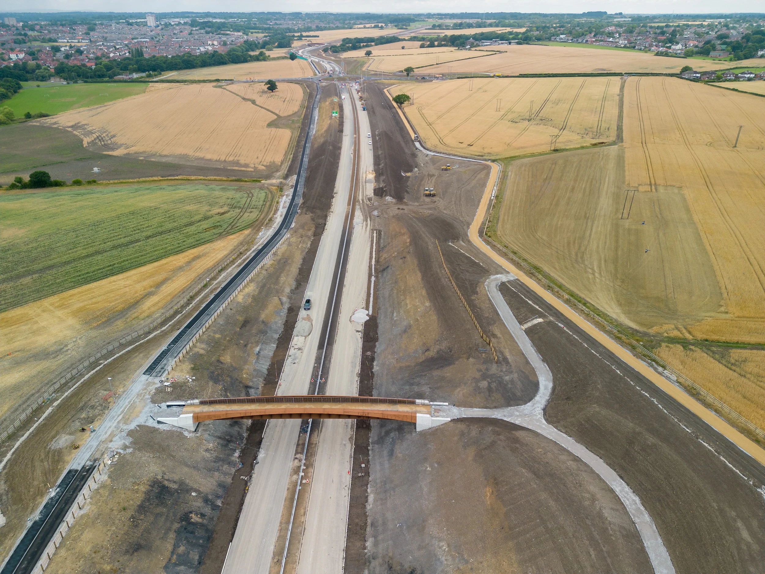
7B. Construction Progress. When Stakeholders Can't Visit the Site
Dataset Credit- Dyan Gorman, Pilotbyte
Situation
A contractor needed a reliable way to update remote investors and design partners.
Challenge
Photos weren't enough. Drone footage didn't answer detailed questions. 360s fixed the viewer to specific points.
What 3DGS Achieved
Stakeholders could explore freely:
check over excavations and structures
revisit areas of interest
compare progress
reduce clarifying emails and meetings
Outcome
Meetings became shorter. Understanding improved. Travel reduced. Communication friction dropped dramatically.
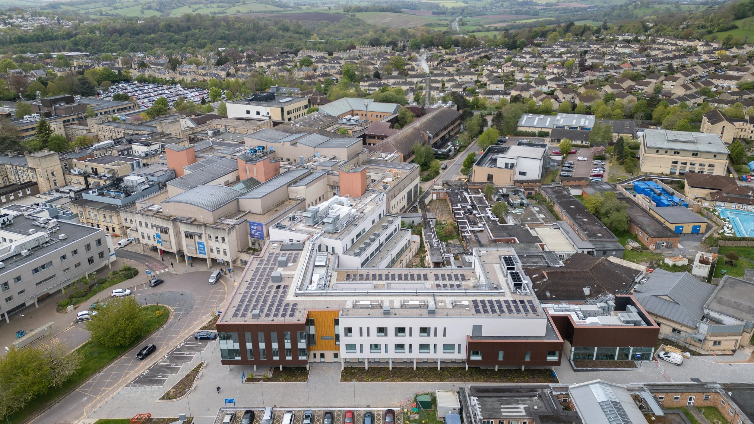
7C. Hospital Update. When a Single Image Isn't Enough
Situation
A team preparing marketing for a new addition to a hospital needed to communicate the update clearly, whilst showcasing their unique building in a countryside setting. Designed by Foster+Partners in 2010, the setting and appearance of the building was a priority.
Challenge
Static images lacked sequence. 360s felt disjointed.
What 3DGS Achieved
A unified, explorable model allowed:
better orientation
clearer route planning
intuitive understanding
showcase of the main building and new addition
Outcome
A clear, interactive visual asset that can be used by several teams.
8. Live Examples: What Gaussian Splatting Looks Like
Gaussian Splatting is best understood visually. This section shows how the technology behaves, how spaces look, how light moves, and how freely the viewer can explore.
Theme-park Church
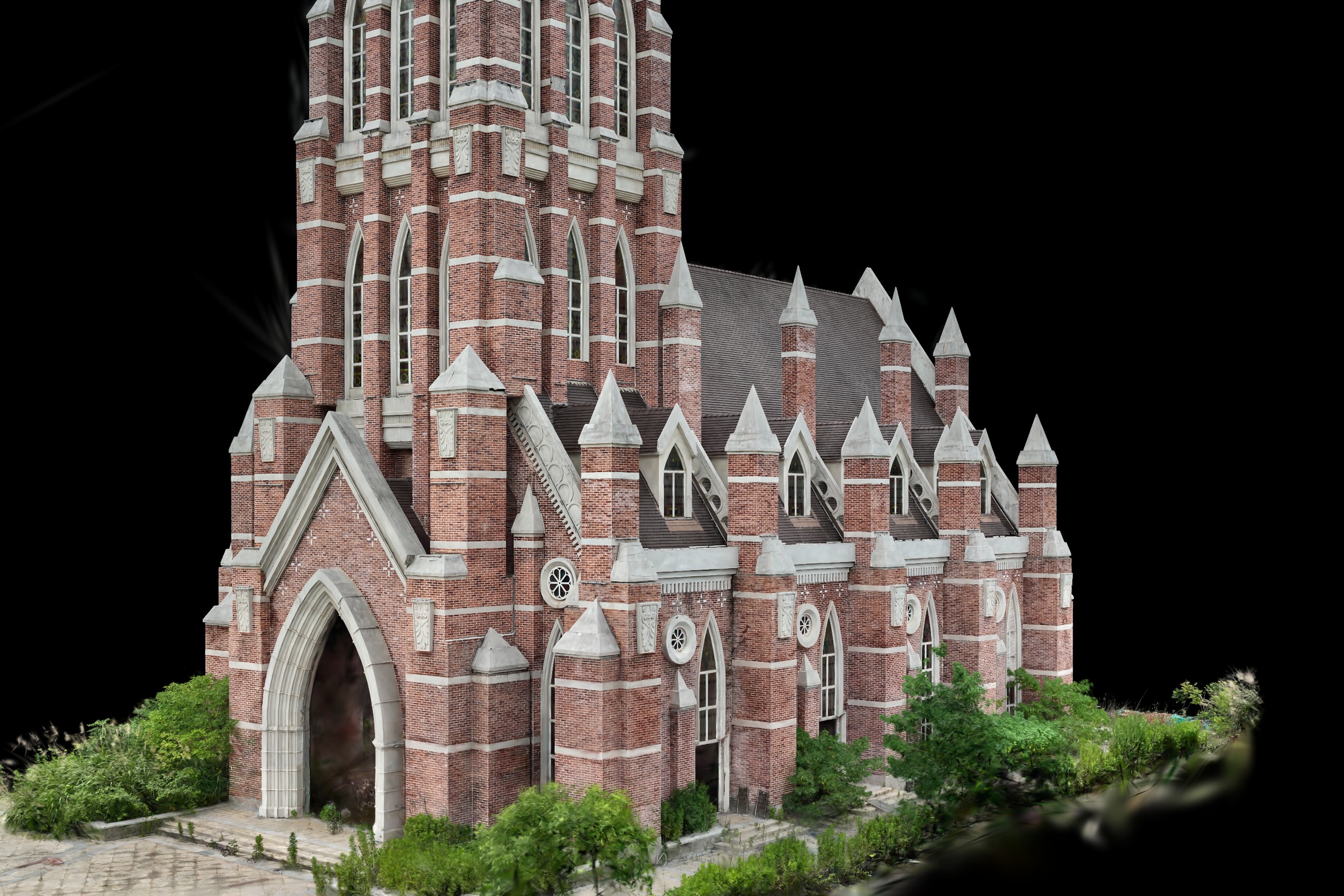
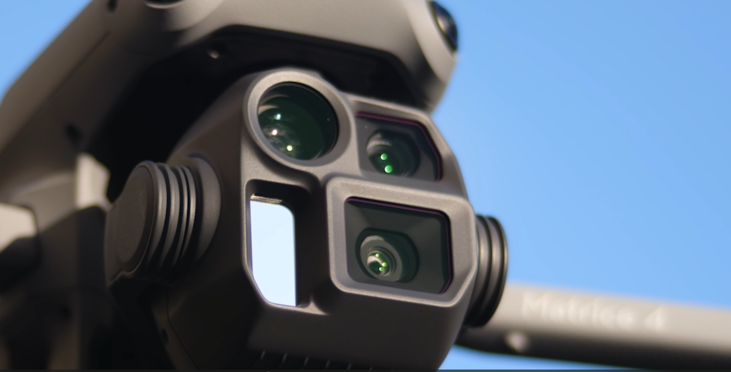
This model was created using the DJI M4E, the latest visible light mapping drone from DJI. I spoke about the drone's autonomous capture ability previously here.
A brief overview is that the M4E can capture a large amount of images around a structure autonomously, this leads to a very detailed model and is now my preferred method. Thank you to MipMap for sharing the dataset.
I'll be creating some more models on the M4E myself so make sure to keep an eye out for updates.
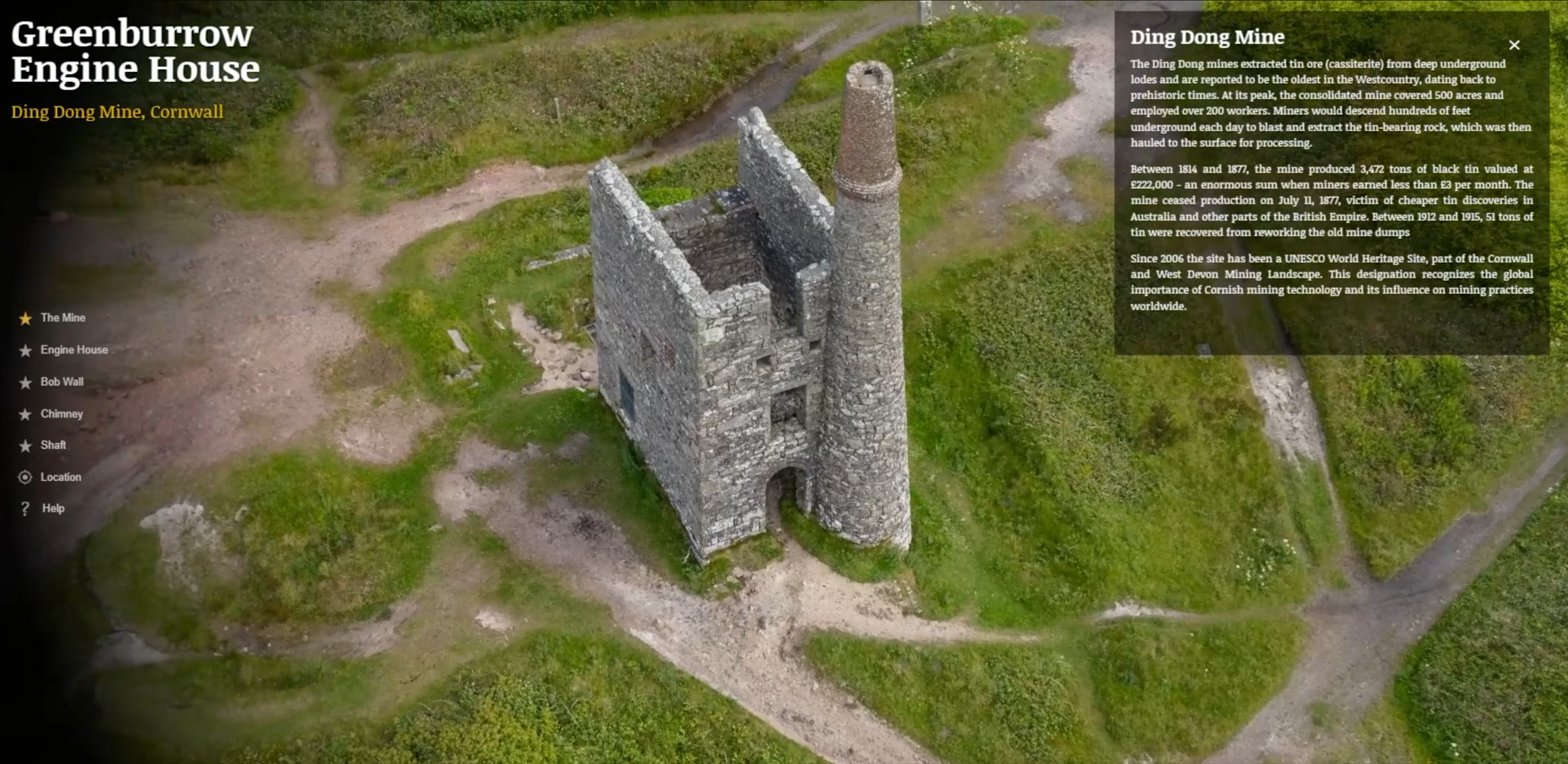
Greenburrow Engine House
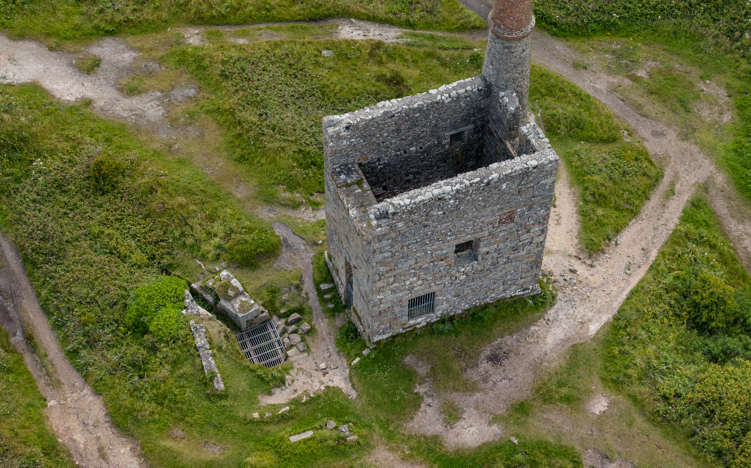
Greenburrow Engine House is one of the pumping stations at Ding Dong Mine, Cornwall - a UNESCO World Heritage Site showcasing the region's industrial mining heritage through preserved granite engine house structures.
Interactive buttons are throughout the 3D model - click on various features to be automatically guided to them with information popups providing historical context.
Heritage House
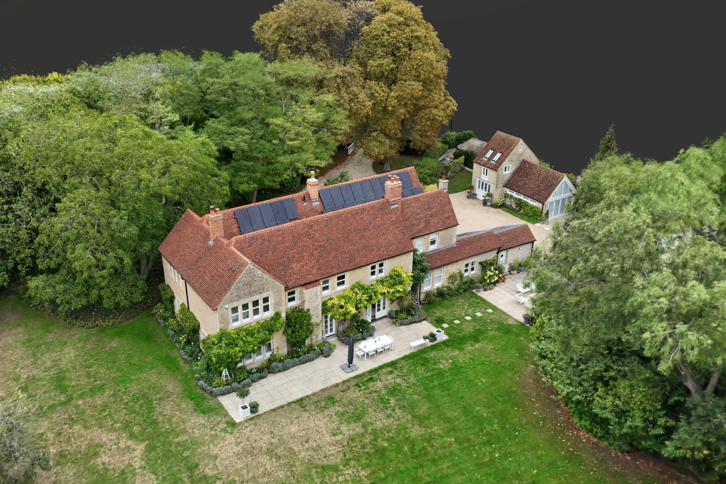
This model was created to showcase the converted and updated residence and its carriage house, alongside its mature grounds.
9. How Gaussian Splatting Is Created: Our Workflow
Every project begins with the same goal: to create a model that looks like the real building or space.
Here's how I approach the process from start to finish.
Step 1. Understanding What You Need
Before any cameras come out, I ask:
What is this model for?
Who will view it?
Which areas matter most?
What story should the building or space tell?
Are there access or timing constraints?
The answers shape the capture plan.
Most conversations begin with a simple question: "What do you need people to understand when they explore this space?"
Step 2. Planning the Capture
Ground Photography
I plan camera paths that capture:
Elevations and facades from ground level
Interior spaces
Thresholds from outside to inside
Hidden detail under trees or building overhangs
Drone Photography
Advanced survey grade drones are used to capture:
Site wide context
Relationships between buildings
Roof detail and MEP plant layout
Elevation and facade detail from higher up
Lighting Strategy
3DGS captures light the exact way it appears in real life so if you want a flatter but more neutral look, we will capture it on an overcast day. If you want a dramatic or brighter scene, we can capture on a sunny day preserving how that light and shadow interact.
This also applies to interiors, with the option of flatter lighting with less shadows, or a more atmospheric scene.
The aim is simple: capture the building in a way that will make sense for the final viewer.
Step 3. Capturing the Photographs
Using ground cameras or drones, we will capture a large amount of images of every angle of the space. Hundreds to thousands of images may be required, depending on complexity and size.
Overlapping coverage ensures the software will have sufficient data to reconstruct the space accurately:
systematic routes through interiors and around exteriors
multiple heights where possible (ground level, elevated positions from various heights)
coverage of all key surfaces and areas
Step 4. Processing the Model
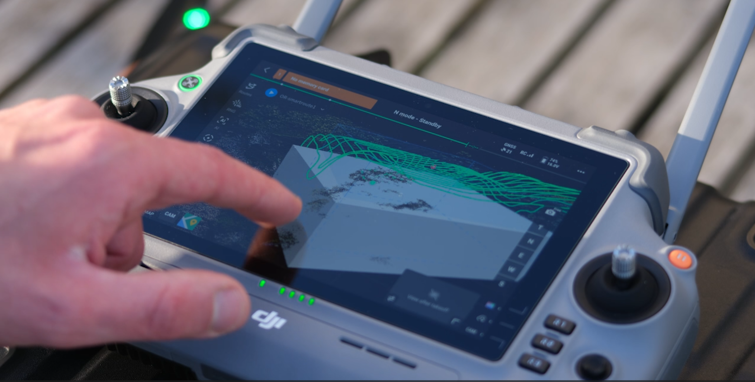
Once images are captured, we process them through specialised software that:
Analyses camera positions using SfM (Structure from Motion), GPS and RTK data
Generates a point cloud creating the raw structure of the space
Trains the Gaussian Splatting model, creating and optimising millions of Gaussians until they match the input photographs, recreating the space in 3D.
The final goal is always the same: the model should feel like standing in or around the building.
Step 5. Delivery and Integration
Once the model is finished it needs to be presented in the correct way. It can be:
embedded on a website
made into a 3D tour with info popups
integrated into a traditional 360° tour
used in stakeholder presentations
packaged for offline public exhibitions
combined with stills or other information
Navigation and UI is kept simple and intuitive so anyone, technical or not, can explore confidently. Any user interface can be added to a 3DGS model.
10. Commissioning Guide: When Gaussian Splatting Is the Right Choice
3DGS is powerful, but not suitable for use everywhere. This guide helps teams understand when it's the right tool.
10A. When Gaussian Splatting Is the Right Choice
✔ When visual quality matters
✔ When you want people to understand the feel of a space
✔ When fixed 360s or video aren't enough
✔ When stakeholders are remote
✔ When documenting heritage sites for public viewing
✔ When you need to reduce site visits
✔ When you want photorealism without synthetic looking 3D
✔ When atmosphere is important
✔ When showing complex geometry or structures
10B. When It's Not the Right Choice
✘ When millimetre-accurate measurement is required
✘ When areas cannot be photographed from all angles
✘ If you want a model purely for BIM, CAD etc.
10C. Assess if 3DGS is Right for You - Commissioning Checklist
Use this checklist to decide whether Gaussian Splatting is the right tool for your project and to prepare the information needed for an accurate scope. It's designed to help architects, contractors, heritage teams and estates managers think through the objectives, access requirements and deliverables before commissioning a model.
Share it internally with your team or include it in early project briefs so everyone involved is aligned on how the model will be used and what it needs to achieve.
PROJECT TYPE
☐ Heritage
☐ Construction
☐ Campus / estates
☐ Design presentation
☐ Public engagement
☐ Marketing
OBJECTIVES
☐ Material clarity
☐ Spatial understanding
☐ Reduce site visits
☐ Preservation
☐ Stakeholder communication
☐ Archive
DELIVERABLES
☐ 3DGS model
☐ 3DGS model in a full 3D tour (popups, annotations, guided views etc)
☐ 3DGS + 360 hybrid
☐ 3DGS + photography
11. Engagement Options: How Gaussian Splatting Fits Into a Project
Every project starts with the same questions:
What needs to be captured (interior, exterior, or both)
One capture or several, Before and After etc.
Building size and complexity
Access constraints
Who will use the model
How it will be delivered
What varies is the output - and which combination best serves the brief.
Output Options
Standalone Gaussian Splatting Model
A photorealistic, freely navigable 3D tour. Works well for heritage interpretation, design communication, and public engagement where visual quality matters most.
3DGS + 360° Hybrid Tour
Combines the benefits of 3DGS with a traditional 360 Tour. Suits estates teams, facilities management, campus documentation, or anywhere users need both immersion and real hi-res photographs.
3DGS + Architectural Photography
Pairs spatial exploration with composed stills. Strong for competitions, presentations, and marketing where you need both atmosphere and clarity.
Construction Progress Documentation
3DGS captured at multiple stages. Useful for contractors, remote stakeholders, and investors tracking progress without repeated site visits.
Public-Facing and Consultation Models
Models built for exhibitions, planning applications, or funding bids. May need simplified navigation, annotations, or specific requirements.
Combining Outputs
Often the strongest results come from combinations:
3DGS + Photography
3DGS + 360 + Stills
Each building dictates the right blend.
12. Conclusion: A New Way to See Buildings Clearly
Gaussian Splatting is more than a new technology. It is a new way to help people understand buildings.
It sits between the tools we already use, bridging their gaps, enhancing their strengths and revealing qualities that usually get lost: materiality, atmosphere, sequence, light, depth and character.
For architects, it communicates design intent with clarity. For contractors, it makes progress understandable. For heritage bodies, it preserves what other methods don't. For estates teams, it offers a unified, long-term visual record.
The technology is stable, the workflows are proven, and the results speak for themselves.
And perhaps most importantly, it gives viewers something simple and rare: the sense of being there.
If you have any questions about Gaussian Splatting, read the FAQ’s below, or get in touch.
Have you used it yourself, and what were your experiences?
13. Frequently Asked Questions (FAQ)
These are the questions architects, contractors, heritage bodies and estates teams most often ask when first encountering Gaussian Splatting.
The answers are clear, practical and written to help teams make confident decisions.
Why not just shoot a normal drone video instead?
A video is a great way to tell a story, but the viewer can only see what has been shot or edited into the final sequence. They can pause a video but not change the camera angle.
3DGS can look indistinguishable from a video and the viewer can have the final say as to where they look, from what angle and for how long etc.
Is Gaussian Splatting accurate enough for technical survey workflows or BIM?
Not in the way a mesh or laser scanning is. 3DGS preserves visuals, not millimetre-accurate geometry you can measure. For measurement, pair 3DGS with a mesh model. Both can be generated from the same image dataset.
Is this generative AI? Does it invent anything?
No. 3DGS is not generative AI. It reconstructs only what was photographed.
Unlike generative AI, it doesn't create or imagine misleading or false content. Areas with insufficient coverage may show artefacts or gaps rather than invented detail.
How many photographs are needed?
A small section of a building exterior or roof might need 200-500 images. An interior space could require 500-1000. A whole structure or large sites with multiple buildings will need several thousand.
Can 3DGS be used indoors and outdoors?
Yes.
It works well in both environments, provided there is space and light for the cameras to capture the area. Sometimes interiors need to be combined with a LiDAR point cloud for proper alignment.
Sometimes it isn't possible to merge the exterior with the interior in a single model. In these cases the two areas can be linked together with a simple hotspot or button, then the viewer can access each area.
Does it work on mobile devices?
Yes, this is one of the major benefits vs traditional 3D.
3DGS runs in any modern web browser on:
phones
tablets
laptops
desktop computers
No special software required. It also can be used in VR.
How large a site can be captured?
There is no fixed limit. 3DGS scales from:
single rooms
individual buildings
courtyards
large campuses
heritage sites
Can multiple buildings be included in one model?
Yes. Buildings can be captured as individual models or as one continuous area.
How long does processing take?
It can take an hour, a few hours or days to align images and train the model. It depends on the number of input images, how well they align, how far the model is refined/trained for and the computer hardware itself.
What if a space can't be captured fully?
3DGS cannot reconstruct unseen areas or views. If certain spaces are inaccessible or unsuitable to wider drone or ground capture, alternatives include:
supplementary 360s
partial scanning as a separate model
still images or video
The goal is always a coherent final model.
Does it handle reflective or transparent materials well?
Yes. Better than most methods, because 3DGS can render the change in reflections and transparency as the camera moves, just as they do in real life. Complex reflective surfaces will need capture from multiple angles to accurately reconstruct how they appear from different viewpoints.
How is 3DGS different from a photogrammetry mesh?
Photogrammetry prioritises geometry. 3DGS prioritises visual realism.
Normal photogrammetry produces mesh models (triangle surfaces with textures & colour); 3DGS creates millions of 'splats' or blobs that combine to maintain photographic appearance without converting to traditional geometry.
Can 3DGS be combined with 360° tours?
Absolutely. Often the best results come from hybrid approaches:
3DGS for immersion
360 for ultra high resolution viewing
A Mesh for measurement or other outputs
Together they provide a complete visual and technical record.
Can we add labels, hotspots or annotations?
Yes. Within our tour platforms you can add:
text labels
clickable hotspots
external links
guided paths
Videos
Audio
Perfect for training, presentations and stakeholder communication.
What about privacy or sensitive locations?
3DGS can be shot, created and delivered offline without the need for cloud services.
In occupied spaces, people can be removed from the model.
The workflow can match your security policies.
14. How to Explore Gaussian Splatting for Your Building or Project
Gaussian Splatting and 360° documentation are most powerful when shaped around your building and the story you need to tell. If you're considering this for a project or simply want to understand what's possible, I'm happy to talk through options.
Choose the path that fits your work:
For 360° Tours, Gaussian Splatting & 3D Documentation
If you want clearer communication with stakeholders, reliable documentation, or a photorealistic record of your building:
For Architectural Photography and Video
If you have a project that deserves careful, atmospheric photography or video:
Email: will@williambeck.net
Book a Call: https://calendly.com/will-williambeck/30min
Website: https://www.williambeck.net
About Will Beck
Will Beck is a specialist working at the intersection of architectural photography, 360° virtual tours, and next-generation 3D documentation technologies such as Gaussian Splatting.
Will now collaborates with architects, contractors, heritage bodies and estates teams to produce 3D visual documentation that is:
photorealistic
intuitive to explore
accurate to material character
accessible for non-technical audiences
robust for long-term reference
His background in architectural photography underpins everything he creates. The same attention to light, colour accuracy and space appears throughout his 3DGS models, 360 tours and still photography.
Whether documenting a heritage façade, capturing construction progress, or developing a hybrid 3DGS + 360 experience, Will's focus is consistent: make the building easier for people to see, understand and remember.
About the ‘Architectural Imagery & 3D’ Newsletter
‘Architectural Imagery & 3D’ is where I share the craft behind architectural imagery, Virtual & 3D tours to help clients and stakeholders feel, understand and remember your sites.
The News letter is also published on LinkedIn, subscribe and connect - https://www.linkedin.com/pulse/new-way-see-buildings-3d-gaussian-splatting-3dgs-heritage-beck-ng7yf
Expect practical, non-technical ideas, advice and opinions on commissioning and using visuals – from photography and virtual tours to 3D capture and drone views – so your buildings are clearer to everyone who needs to experience them.
I will also share opinions, behind the scenes, and projects. I will break down what works (and what doesn’t) when you use visuals for bids, approvals, stakeholder engagement, marketing, wayfinding and public communication.
If you work with buildings, spaces or places - designing them, managing them, restoring them, or presenting them - this is for you.